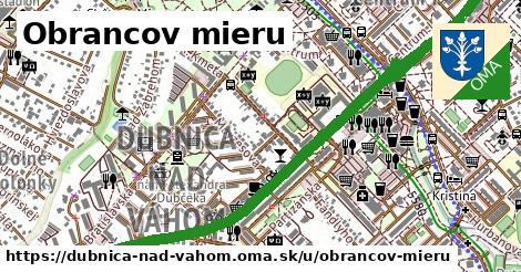
čísla, 1 z 2
1 ¤, 10 ¤, 11 ¤, 12 ¤, 13 ¤, 1384 ¤, 14 ¤, 15 ¤, 16 ¤, 17 ¤, 18 ¤, 19 ¤, 2 ¤, 20 ¤, 21 ¤, 22 ¤, 23 ¤, 24 ¤, 25 ¤čísla, 2 z 2
26 ¤, 27 ¤, 28 ¤, 29 ¤, 3 ¤, 30 ¤, 31 ¤, 32 ¤, 33 ¤, 35 ¤, 36 ¤, 38 ¤, 4 ¤, 5 ¤, 6 ¤, 7 ¤, 8 ¤, 9 ¤Obchod
Papiernictvo Penguin ¤, Hračky Penguin ¤, Střelná ¤, kvetinárstvo ¤, Potraviny Koruna ¤, PC - servis.sk ¤, FARBY - LAKY ¤, Kvety u Guru ¤, Pepco ¤, KLINGO-SPORT ¤, O2 ¤, Billa ¤, dm ¤, SWAN, a.s. ¤, KiK ¤, JYSK ¤, Obchodný dom Máj ¤, Obchodný dom Astra ¤, Deichmann ¤, Kaufland ¤, chovprodukt ¤, Stop Shop ¤, Takko Fashion ¤, dm ¤, PLANEO Elektro ¤, Záložňa Breva ¤, Orange ¤, Jadranská zmrzlina ¤, COOP Jednota ¤, Suave gelato ¤Stravovanie
Šport club bar ¤, Omnia bar ¤, Sedmička ¤, Poľovník ¤, Bistro Kolonky ¤, Garage pub ¤, Galéria ¤, Šport bar ¤, Soul café & bookstore ¤, Fontána ¤, Kebab JM ¤, Gaudeamus ¤, Captain's pub ¤, Plaza Cafe ¤, X pub ¤, Vix ¤, Route Grill 50 ¤, Pizza fantastica ¤, AG Play ¤, Bistro 33 ¤, Per lei ¤, Tabak press, Bressman ¤, Chelsea pub ¤, Street Food Dubnica ¤, Dubnický hamburger ¤, Čarovná špajza ¤, Admiral ¤, Piváreň u Tuláka ¤, Dubnický hamburger ¤, automat na mlieko ¤Turistika
orientačný bod ¤, orientačný bod ¤, prístrešok, altánok ¤, prístrešok, altánok ¤, prístrešok, altánok ¤, prístrešok, altánok ¤, prístrešok, altánok ¤, prístrešok, altánok ¤, prístrešok, altánok ¤, prístrešok, altánok ¤, orientačný bod ¤, Horné jutrá niže hradskej ¤, komín ¤, komín ¤šport
detské ihrisko ¤, ihrisko ¤, ihrisko ¤, basketbal ¤, ihrisko ¤, detské ihrisko ¤, detské ihrisko ¤, ihrisko ¤, detské ihrisko ¤, ihrisko ¤, futbal ¤, detské ihrisko ¤Voľný čas
park ¤, Fortuna ¤, Fun Caffe ¤, miesto na uviazanie psov ¤, park ¤, park ¤, Mestská knižnica Dubnica nad Váhom ¤Služby
kôš ¤, kôš ¤, kôš ¤, kôš ¤, kôš ¤, kôš ¤, kôš ¤, kôš ¤, Prima banka ¤, Všeobecná úverová banka ¤, číslo S6AV372I ¤, bankomat ¤, Dopravný inšpektorát Trenčín, pracovisko Dubnica nad Váhom ¤, Poštová banka ¤, bankomat ¤, Obvodné oddelenie policajného zboru Dubnica nad Váhom ¤, Oddelenie dokladov ¤, ČSOB ¤, Raiffeisen banka ¤, číslo S6AV372P ¤, Dubnica nad Váhom 10 ¤, Slovenská sporiteľňa ¤, bankomat ¤, Mestský úrad ¤Doprava
Dubnica n.V.,SPŠ ¤, Dubnica n.V.,SPŠ ¤, Dubnica n.V.,SPŠ ¤, Dubnica n.V.,SPŠ ¤, Dubnica n.V.,SPŠ ¤, Dubnica n.V.,SPŠ ¤, Dubnica n.V.,SPŠ ¤, Dubnica n.V.,SPŠ ¤, Dubnica nad Váhom, Tesco ¤, Dubnica nad Váhom, Tesco ¤, Dubnica n.V.,Kolonky ¤, Dubnica n/V, Rozptyl ¤, Dubnica n.V.,Kolonky ¤, Dubnica n/V, Rozptyl ¤, Dubnica nad Váhom, Kollárova ¤, Dubnica nad Váhom, ABC ¤, Dubnica nad Váhom, ČSA ¤, Dubnica nad Váhom, ABC ¤, Dubnica n/V, rázc. Hviezdoslavova ¤Auto
parkovisko ¤, parkovisko ¤, parkovisko ¤, parkovisko ¤, parkovisko ¤, parkovisko ¤, parkovisko ¤, parkovisko ¤, parkovisko ¤, parkovisko ¤, parkovisko ¤, parkovisko ¤, parkovisko ¤, parkovisko ¤, parkovisko ¤, parkovisko ¤, parkovisko ¤, parkovisko ¤, Tesco ¤, parkovisko ¤, parkovisko ¤, parkovisko ¤, Slovnaft ¤, parkovisko ¤, parkovisko ¤, parkovisko ¤, parkovisko ¤, parkovisko ¤, parkovisko ¤, parkovisko ¤Zdravotníctvo
Veterinárna ambulancia ¤, Benu ¤, Lekáreň na námestí ¤, Dr. Max ¤, Máj ¤, Lekáreň Pod Hájom ¤Vzdelanie
Stredná priemyselná škola ¤, Materská škola Centrum II ¤, stredná škola ¤, Materálovotechnologická fakulta STU, detašované pracovisko Dubnica nad Váhom ¤, Centrum voľného času ¤, Stredná odborná škola ¤Bicykel
Bike Centrum ¤, Cyklo 105 ¤, Tesco ¤, Slovnaft ¤, Dalioil ¤, cyklopumpa ¤, cyklostojan ¤, miesto na uviazanie psov ¤, cyklostojan ¤, cyklostojan ¤, Slovkolex ¤Prístupnosť
parkovisko ¤, parkovisko ¤, parkovisko ¤, parkovisko ¤, parkovisko ¤, Z-Box ¤, parkovisko ¤, parkovisko ¤, parkovisko ¤, parkovisko ¤, parkovisko ¤, Podzemné parkovisko na námestí ¤, parkovisko ¤, JYSK ¤, Obvodné oddelenie policajného zboru Dubnica nad Váhom ¤, parkovisko ¤, parkovisko ¤, parkovisko ¤, parkovisko ¤, parkovisko ¤, parkovisko ¤, parkovisko ¤, parkovisko ¤, parkovisko ¤, parkovisko ¤, parkovisko ¤, Z-Box ¤, Tesco ¤, parkovisko ¤, parkovisko ¤